AOMORI PREFECTURE LIVE CAMERAS

Sponsored links
Hakkoda Mountains, Aomori PrefectureTOHOKU
Hakkoda Mountains, Aomori Prefecture

Sponsored links

Aomori Prefecture Live Cameras

Aomori City

  • Iwaki River / Mabechi River (Aomori City)  / River Information in Aomori Prefecture Iwaki River Mabechi River / Aomori River National Highway Office
  • Furukawa, Aomori City  / Citizen’s Windmill Business / Green Energy Aomori
  • Aomori City  / Tsurugasaka Sengari Line, Yanagimachi Dori, Matsubara Dori, Fujita Gumi Dori, Akira no Hoshi Dori, etc./My town corner information Aomori
  • Aomori City  / National Highway No. 7 / Ring Road, National Highway No. 4 / Aomori National Highway Maintenance Branch Office
  • Arakawa Shibata, Aomori City / ABA Live Camera, Aomori City / Asahi Broadcasting Aomori Headquarters
  • Aomori Airport (Otani, Aomori City)  / “Aomori Airport Live Camera” Aomori Airport Management Office / Aomori Prefectural Office
  • Aomori Airport (Otani, Aomori City) / RAB Aomori Airport Live Camera / Aomori Broadcasting Corporation (RAB)
  • Aomori Airport (Otani Kotani, Aomori City) / ABA Aomori Asahi Broadcasting Weather Camera Aomori Airport / ABA Aomori Asahi Broadcasting
  • Aomori Airport (Otani, Aomori City) / ATV Aomori Airport Live Camera / Aomori Television (ATV)
  • Sukayu Onsen / Sukayu Onsen Live Camera / National Recreation Hot Spring Sukayu Onsen Ryokan (Aomori City Arakawa Minami Arakawayama National Forest Sukayuzawa)
  • Jigokunuma (Aomori City Arakawa Minamiarakawayama National Forest Acid Gayuzawa ) / Hakkoda Mountain Jigokunuma Live Camera / Japan Meteorological Agency
  • Aomori City Myoken / Tsutsumikawa Shin Myoken Bridge Live Camera / Ministry of Land, Infrastructure, Transport and Tourism River Information Center
  • Harabetsu, Aomori City / Numakawa Daiichi Shimo Unabara Bridge Live Camera / Ministry of Land, Infrastructure, Transport and Tourism River Information Center
  • Aomori City Takizawa Shimokawara / Nonai River Takizawa Live Camera / Ministry of Land, Infrastructure, Transport and Tourism River Information Center
  • Aomori City Yahatabayashi Shinagawa / Nonai River Shinnouchi Bridge Live Camera / Ministry of Land, Infrastructure, Transport and Tourism River Information Center
  • Okunai Miyata, Aomori City / Okunai River Toyogenbashi Live Camera / Ministry of Land, Infrastructure, Transport and Tourism River Information Center
  • Aomori City Rokumaibashi / Rokumaebashi River Rokumaibashi Live Camera / Ministry of Land, Infrastructure, Transport and Tourism River Information Center
  • Aomori City Aburakawa Funaoka / Amatanai River Aburakawa Live Camera / Ministry of Land, Infrastructure, Transport and Tourism River Information Center
  • Aomori City Shinjo Hiraoka / Shinjo River Shinjo Live Camera / Ministry of Land, Infrastructure, Transport and Tourism River Information Center
  • Aomori City Namioka Daishaka Yamada / Daishaka River Daishaka Bridge Live Camera / Ministry of Land, Infrastructure, Transport and Tourism River Information Center
  • Aomori City Namioka Daishaka / National Route 7 Namioka Bypass Daishaka Live Camera / Aomori River National Highway Office
  • Aomori City Namioka Namioka Sano / Akakawa Sanobashi Live Camera / Ministry of Land, Infrastructure, Transport and Tourism River Information Center
  • Aomori City Namioka Hongo Matsumoto / Hongo River Comb Sugibashi Live Camera / Ministry of Land, Infrastructure, Transport and Tourism River Information Center
  • Shinoda, Aomori City / Okidate River Okidate River Downstream Live Camera / Ministry of Land, Infrastructure, Transport and Tourism River Information Center
  • Aomori City Miuchizawabe / Okidate River retarding basin water level live camera / Ministry of Land, Infrastructure, Transport and Tourism River Information Center
  • Takada Kawase, Aomori City / Tsutsumikawa Ohno Live Camera / Ministry of Land, Infrastructure, Transport and Tourism River Information Center
  • Hanazono, Aomori City / Tsutsumikawa Kodabashi Live Camera / Ministry of Land, Infrastructure, Transport and Tourism River Information Center
  • Aomori City Nozawa Kawabe / Tsutsumikawa Oyanagibe Live Camera / Ministry of Land, Infrastructure, Transport and Tourism River Information Center
  • Aomori City Hamanasu / Akakawa Hamanasu Park Live Camera / Ministry of Land, Infrastructure, Transport and Tourism River Information Center
  • Aomori City Asamushi Yamashita / Asamushi River Ginkgo Bridge Live Camera / Ministry of Land, Infrastructure, Transport and Tourism River Information Center
  • Aomori City Shinjo Amadanai / Amatanai River Amatanai River Water Level Observatory Live Camera / Aomori Prefecture River Sabo Information Providing System
  • Aomori City Namioka Namioka Okada / Namioka River Kawaramachi Bridge Live Camera / Aomori Prefecture River Sabo Information Providing System
  • Aomori City Namioka Tokusako / Tsugaru Expressway Tokusako Live Camera / Aomori River National Highway Office
  • Matsumori, Aomori City / RAB Aomori Live Camera / RAB Aomori Broadcasting Corporation
  • Kanehama Inada, Aomori City / Tsutsumigawa Arakawabashi Live Camera / River Sabo Division, Aomori Prefectural Land Development Department
  • Aomori City Ushidate / Tsutsumi River Ushitachi River Confluence Live Camera / Aomori Prefectural Land Development Department River Sabo Division
  • Aomori City Tonyamachi / Tsutsumigawa Wholesale Bridge Live Camera / Aomori Prefectural Land Development Department River Sabo Division
  • Aomori City Tonyamachi / Ring No. 7 Aomori Chuo Intersection Live Camera / Aomori ITS Club
  • Aomori City Tsutsui Yatsuhashi / Tsutsumi River Yokouchi River Confluence Live Camera / Aomori Prefectural Land Development Department River Sabo Division
  • Tsutsui, Aomori City / Live camera near Tsutsumi River Tsutsui Elementary School / River Sabo Division, Aomori Prefectural Land Development Department
  • Matsubara, Aomori City / Tsutsumi River Komagome River Confluence Live Camera / Aomori Prefectural Land Development Department River Sabo Division
  • Sakuragawa, Aomori City / Komagome Kawaminami Sakuragawa Bridge Live Camera / River Sabo Division, Aomori Prefectural Land Development Department
  • Aomori City Tsutsui Sakuragawa / Komagome River Komagomegawa Bridge Live Camera / Aomori Prefectural Land Development Department River Sabo Division
  • Aomori City Tsurugasaka Yamamoto / National Route 7 Tsurugasaka Management Border Live Camera / Aomori River National Highway Office
  • Sumiyoshi Takizawa, Aomori City / Jet Factory Aomori Bay Live Camera / Jet Factory
  • Aomori City Takizawa / Michinoku Toll Road New Akazawa Bridge Live Camera / Aomori Trunk Road Council
  • Arakawa Kansuizawa, Aomori City / National Route 394 Jogakura Ohashi Live Camera / Aomori Trunk Road Council
  • Yaegiku Yokouchi, Aomori City / National Route 103 Kayano Chaya Live Camera / Aomori Trunk Road Council
  • Aomori City Yahatabayashi Shinagawa / National Highway No. 4 Shinnouchibashi Live Camera / Ministry of Land, Infrastructure, Transport and Tourism Tohoku Regional Development Bureau Aomori River National Highway Office
  • Toyama, Aomori City / National Highway No. 7 Ring Toyama Live Camera / Ministry of Land, Infrastructure, Transport and Tourism Tohoku Regional Development Bureau Aomori River National Highway Office
  • Aomori City Sengari / National Route 7 Furukawa Overpass Live Camera / Aomori River National Highway Office
  • Kugurizaka, Aomori City / National Highway No. 4 Kugurizaka Live Camera / Aomori River National Highway Office
  • Aomori City Tokado  / National Route 7 Tokado Live Camera / Aomori River National Highway Office
  • Aomori City Tsurugasaka / National Route 7 Tsurugasaka Live Camera / Aomori River National Highway Office
  • Matsumori, Aomori City / ATV Aomori TV Headquarters Iwakiyama Live Camera / ATV Aomori TV
  • Ono Wakamiya, Aomori City / Live camera near Ono, Central Ohashi Street / Aomori ITS Club
  • Aomori City Komagome Kirinosawa / Ring No. 7 Komagome Intersection Live Camera / Aomori ITS Club
  • Minamitsukuda, Aomori City / Live camera near Ming no Hoshidori Co-op / Aomori ITS Club
  • Aomori City Minamitsukuda / Fujita Gumi Dori Matsumori Intersection Live Camera / Aomori ITS Club
  • Aomori City Matsubara / Matsubara Dori Matsubara Intersection Live Camera / Aomori ITS Club
  • Aomori City Central / Yanagimachi Dori Yamate Live Camera / Aomori ITS Club
  • Aomori City Ishie Edo / Tsurugasaka Sengari Line Live Camera / Aomori ITS Club
  • The Center of Aomori Cityaddress: Aomori City, Aomori, site title: My Town Aomori, Click the third light green banner, “Live camer,” in the left side, and click the red circles in the map. camera titles: (1) Tsurugazaka Chikari Line, from the NTT docomo shop Aomori Nishi (2) National Highway No.4, from the Prefectural Office (3) Yanagimachi Street, from Yamate (4) Chuo Ohashi Street, Ono (5) the Intersection of Aomori Chuo Interchange, Ring Road No.7 (6) the Yatsueki Intersection (7) the Kanko (Tourisum) Street, Hamada (8) Matsubara Street, Matsubara Intersection (9) National Highway No.4 Tsutsumi Bridge, Kanebo (10) Fujitagumi Street, Matsumori Intersection (11) Akenohoshi Street, Co-op (12) Komagome Intersection, Ring Road No.7
  • National Highway No.7 and No.4, address: Aomori City, site title: National Highway Office Aomori, camera title: Aokoku Live (Aomori National Highway Live), Click the small photo images or the black icons in the map. cameras in the first line, from the left: (1) Tsurugazaka, National Highway No.7, (2) Tokado, No.7, (3) Shinjo, No.7, (4) Furukawakosen Bridge, No.7, the second line:(5) Shinnouchi Bridge, No.4, (6) Kuguri Slope, No.4, (7) Tsuchiya, No.4, (8) Myojin Bridge, No.4, (9) Shimizu River, No.4, (10) Karibazawa, No.4
  • Aomori Airport, Aomori City, address: Odani, Aza, Otani, Aomori City, Aomori, site title: Aomori Airport, the official web site, camera title: Aomori Airport Live Camera, the boarding bridge No.3 (spot No.3), Aomori Airport is administrated by Aomori Prefecture. It was open in 1963 and is open from 7:30 to 22:00.
  • Sukayu Onsen, camera title: Sukayu Onsen Live Camera, address: Sukayu Onsen Ryokan, 50 Sukayuzawa, Kokuyurin, Arakawayama, Arakawaminami, Aomori-shi, Aomori-ken 00-0111, site title: Sukayu Onsen
  • Windmill Electricity, address: Furukawa, Aomori City, Aomori, site title: Green Energy Aomori, specified nonprofit corporation, camera title: Civil Windmill Project, The GEA, Green Energy Aomori, is the nonprofit organization for the realization of recycling society and reginal independence.It rus the project of windmill electricity. The project is run by the fund of citizens.

Hirosaki City

Kuroishi City

Goshogawara City

Tsugaru City

Hirakawa

Hiranai Town

Imabetsu Town

Yomogita Village

Sotogahama Town

  • Sotogahama Town Tairadate Negishi Yunosawa / Yunosawa River Tsurugamebashi Live Camera / Ministry of Land, Infrastructure, Transport and Tourism River Information Center
  • Kanita Oguni Iwai, Sotogahama- cho, Higashitsugaru-gun / Kanita River Minamizawa Live Camera / Ministry of Land, Infrastructure, Transport and Tourism River Information Center
  • Sotogahama Town Kanita Kawarazoe / Kanita River Ipponmatsu Ohashi Live Camera / Ministry of Land, Infrastructure, Transport and Tourism River Information Center
  • Ryuhizaki Lighthouse, address: Sotogahama-cho, Higashi Tsugaru-gun, Aomori, site title: Aomori Maritime Information and Communication System, camera title: Ryuhizaki Lighthouse Live Camera, Click the second Japanese link, “Ryuhizaki Todai Live Camera,” in the Section 3 in the menu in the left side of the site.

Ajigasawa Town

Fukaura Town

Nishimeya Village

Fujisaki Town

Owani Town

  • Owani Nijikai Shinozuka / Hirakawa Hirakawa Daiichi Headworks Live Camera / Ministry of Land, Infrastructure, Transport and Tourism River Information Center
  • Owani Town Owani Kawabe / Hirakawa Owani Live Camera / Ministry of Land, Infrastructure, Transport and Tourism River Information Center
  • Owani Karouji, Minamitsugaru-gun / National Highway No. 7 Owani Karouji 2nd Live Camera / Aomori River National Highway Office
  • Owani Karouji, Minamitsugaru-gun / National Highway No. 7 Owani Karouji 2nd Live Camera / Aomori River National Highway Office
  • Owani-cho, Minamitsugaru-gun Owani Nagamine Sunazawatai / Tohoku Expressway Ayura PA Live Camera / NEXCO East Japan
  • Owani Town, Minami Tsugaru-gun,address: Owani-cho, Minamitsugaru-gun, Aomori, site title: Owani Town, the town of sky, hot spring and apple, camera title: Owani Town Live Camera, Click the blue banners in the middle of the site. Owani Town is the southern part of Tsugaru District in Aomori, and known for the town of sky, hot spring, apple and sightseeing. The population is eleven thousand in July, 2012.

Inakadate Village

Itayanagi Town

Tsuruta Town

Nakadomari

Mutsu City

Oma Town

Higashidori Village

Kazamaura Village

Sai village

Hachinohe

Towada City

  • Towada City  / Lake Towada, Towada City Hall Street (also known as Koma Kaido) / Towada City Hall
  • Towada City / National Highway No. 4 (Nobeji Town, Tohoku Town, Shichinohe Town, Towada City, Gonohe Town Ogita, Gonohe Town Jinba, Sannohe Town Umeuchi), Kamikita Road Rokunohe Town / Towada National Highway Maintenance Branch Office
  • [Stopped] Towada City  / Veterinary School Building and Towada City Townscape / Kitasato University Veterinary School
  • Towada City Horyo Ginnagi / Oirase River Horyo Live Camera / Ministry of Land, Infrastructure, Transport and Tourism River Information Center
  • Towada City Oaza Sanbongi Yagami / Oirase River Chuseri Live Camera / Ministry of Land, Infrastructure, Transport and Tourism River Information Center
  • Towada City Kamikamoiri / Oirasegawa Aisaka Live Camera / Ministry of Land, Infrastructure, Transport and Tourism River Information Center
  • Towada City Oaza Lake Towada Closed / Lake Towada Marina Live Camera / Lake Towada Marina
  • Towada City Oaza Denpoji / National Route 4 Towada Denpoji Live Camera / Aomori River National Highway Office
  • Towada City Oaza Okuse Lake Towada Closed / Lake Towada Closed Area Live Camera / Towada City Hall
  • Lake Towada, Towada City, camera title: Lake Towada, address: Towada-shi, site title: Towada City Official Web Site

Misawa City

  • Misawa Airport, Misawa City, address: Shimo Yuzawa, Misawa, Misawa City, Aomori, 033-0022, site title: Misawa Airport Terminal Co., Ltd. camera title: Airport Live Cam, the present status of Misawa Airport

Noheji Town

Shichinohe

Rokunohe

Yokohama town

Tohoku Town

Rokkasho Village

Oirase Town

Sannohe Town

  • Kawamorita Sekinekawara, Sannohe-gun, Sannohe-Kumahara River Kawahara Bridge Pedestrian Bridge Live Camera / Aomori Prefecture River Sabo Information Providing System
  • Oaza River Morita Hashinoshimo, Sannohe District, Sannohe District / Kumahara River Tomegasaki Bridge Live Camera / River Sabo Division, Aomori Prefectural Land Development Department
  • Sannohe-gun Sannohe-cho Oaza Umenai / National Route 4 Sannohe Umenai Live Camera / Aomori River National Highway Office

Gonohe Town

Takko Town

  • Gorin Yamaguchi, Takko-cho, Sannohe-gun / Kumahara River Ochiai Bridge Live Camera / Ministry of Land, Infrastructure, Transport and Tourism River Information Center
  • Takko Tako, Takko- cho, Sannohe-gun / Tanegawa Bad Dobashi Live Camera / River Information Center, Ministry of Land, Infrastructure, Transport and Tourism
  • Takko Town Kampaku Hagihira / National Route 104 Hakuhagihei Live Camera / Aomori Trunk Road Council

Nambu town

Hashikami Town

Shingo Village

All over the prefecture

  • Shimokita, address: Mutsu City, Yokohama-cho, Sai-mura, Kazamaura-mura, site title: e-Shimokita Net, camera titles, from the left, (1) the park of Kawauchi waterfalls (2) the park of Isaribi, Kazamaura-mura (3) the observatory Sai Hotokegaura (4) the park of monkeys Wakinosawa (5) road slope monitoring system
  • National Highways, address: Aomori City, site title: The Rivers and Road in Aomori, National Highway and Rivers Office Aomori, Tohoku Regional Development Bureau, Ministry of Land, Infrastructure and Transportation, camera title: Aomori Road Information Live Camera, Click the camera icons in the map or the photos below the map. view of National Highway No.7, No.101, No.4, No.104, No.45, and the Ring Road Hachinohe Minami
  • Rivers,address: Aomori, site title: The Rivers and Roads in Aomori, National Highway and Rivers Office Aomori, camera titles: three ares in the map, which are surrounded by the line, are as follows, from the left (1) Downstream Iwaki River, (2) Upstream Iwaki River, (3) Mabuchi River, Click the areas, then the cameras in each area map.
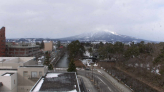
  • Mutsu Bay, Mt. Iwaki, Hachinohe Portsite title: ATV Aomori Television Broadcasting Co., Ltd., camera titles, three cameras, from the top, (1) Mutsu Bay from the ATV headquarters in Aomori City (2) Hirosaki Park and Mt. Iwaki in Hirosaki City (3) Hachinohe Port and Hachinohe Bridge in Hachinohe City
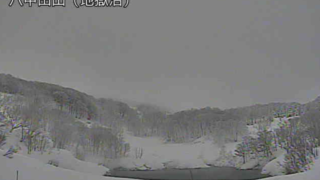
  • 【in adjustment】Mt. Iwaki, Hirosaki Park, Hakkodasan, Mutsu Bay, etc., Aomori, URL: http://mylex.cc.hirosaki-u.ac.jp/, address: Aomori, site title: Aomori Live Camera, 15 cameras in the site, from the left, the first line: (1) Mt. Iwaki, from Hirosaki University (2) Mt. Iwaki 2, from Hirosaki University (3) Aomori City Area, from Aomori Prefectural Tourist Center, the Aspam, the second line: (4) Shirakami Mountain Range, from Hirosaki University (5) Sky Area Owani, from Hirosaki University (6) Sky Area Moyahills, from the Aspam, the third line: (7) Hirosaki Park (Otemon), from Hirosaki City Office (8) Hirosaki Park 2 (Otemon), from Hirosaki City Office (9) Hall Hirosaki Tourism, from the City Office, the fourth line: (10) Hakkodasan, from Hirosaki University (11) Hakkodasan 2, from Hirosaki University (12) Hakkodasan, from the Aspam, the fifth line: (13) Blue Ocean Park (West), from the Aspam, (14) Mutsu Bay, from the Aspam (15) Blue Ocean Park (East), from the Aspam
  • Yatate Pass, camera title: Yatate Pass Live Camera, site title: Yatate NAVI
error:Content is protected !!