GUNMA PREFECTURE LIVE CAMERAS

Sponsored links
Kusatsu Onsen, Gunma PrefectureKITAKANTO
Kusatsu Onsen, Gunma Prefecture
Sponsored links

Gunma Prefecture Live Cameras

Maebashi City

Roads

Route 17

Rivers

Akagishirakawa River
Kanzawa River
Hirose River
  • Sunaga Bridge, Hirose River 15.3K | Shimomasuda Town, Maebashi City, Gunma Prefecture 379-2113 | Ministry of Land, Infrastructure, Transport and Tourism
  • Ochiai Bridge, Hirose River 16.2K | Koyaharamachi, Maebashi City, Gunma Prefecture 379-2121 | Ministry of Land, Infrastructure, Transport and Tourism river disaster prevention information
  • Kamihashi Bridge, Hirose River 17.0K | Koyaharamachi, Maebashi City, Gunma Prefecture 379-2121 | Ministry of Land, Infrastructure, Transport and Tourism river disaster prevention information

Takasaki City

  • Mt. Sumomogadake | Iwanaga, Kurabuchi Village, Takasaki City | Welcome to Kurabuchi Village
  • Hamayu Sanso | Hamayu Sanso (mountain cottage), 27-80 Kawaura, Kurabuchi-machi, Takasaki-shi, Gunma Prefecture 370-3405 | Hamayu Sanso
  • Mt. Haruna | Warabidaira Forest Park Camp Site, 27-9 Kawaura, Kurabuchi-machi, Takasaki City, Gunma Prefecture 370-3405 | Warabidaira Forest Park Campsite
  • Tozenji Temple Garden | Tozenji Temple, 169 Gonda, Kurabuchi-machi, Takasaki-shi, Gunma 370-3401 | Tozenji
  • Mt. Haruna and Lake Haruna |Harunako Romancetei, 848 Harunako-machi, Takasaki City, Gunma Prefecture 370-3348 | Lake Haruna Romance Tei

Roads

  • National Highways and Rivers, address: Takasaki River National Highway Office, 6-41 Sakae-machi, Takasaki-shi, Gunma, site title: Takasaki River National Highway Office, Kanto Regional Development Bureau, Ministry of Land, Infrastructure and Transport, The links of the live cameras are below the map. From the top, camera #1: Karasu River, Jonan Ohashi, Shigoka-machi, Takasaki City, Gunma, camera #2: National Highway Route 17, Tateiwa Bridge, Sangoku Tunnel in Niigata Prefecture, camera #3: National Highway Route 17, Joetsu Bridge, Sangoku Tunnel in Gunma Prefecture, Nagai, Minakami-machi, camera #4: National Highway Route 17 Hoshi Bridge, Nagai, Minakami-machi, camera #5: National Highway Route 17 Curve, Nagai, Minakami-machi, camera #6: National Highway Route 17 Sarugakyo Snow Station, 895 Sarugakyo Onsen, Minakami-machi, camera #7: National Highway Route 18 Usui Bypass Highway Karuizawa Bridge, Karuizawa-machi, Kita Saku-gun, camera #8: Mt. Asama (Karuizawa), Karuizawa-machi, Kita Saku-gun
Route 17

Rivers

Ino River
Kabura River
Karasu River

Kiryu City

Roads

Rivers

Kiryu River
Watarase River

Isesaki City

Roads

Rivers

Tone River
Hirose River

Ota City

Roads

Rivers

Okawa River
Tone River
Hayakawa River
  • Hayakawa River Left Bank 0.5K | Horiguchi Town, Ota City, Gunma Prefecture 370-0414 |vers by the Ministry of Land, Infrastructure, Transport and Tourism
  • Hayakawa River Left Bank 1.7K | Horiguchi Town, Ota City, Gunma Prefecture 370-0414 |vers by the Ministry of Land, Infrastructure, Transport and Tourism

Tatebayashi City

  • Tatebayashi City / Tobu Treasure Garden, Morinji Temple, Rotary in front of Tatebayashi Station / Cable TV Corporation
  • Tatebayashi City Tsutsujigaoka Park | Tsutsujigaoka Park General Management Office, 3181 Hanayama-cho, Tatebayashi City, Gunma Prefecture 374-0005 | Tsutsujigaoka Park General Management Office
  • Chiaki Mukai Memorial Children’s Science Museum | Mukai Chiaki Memorial Children’s Science Museum, 2-2 Shiromachi, Tatebayashi City, Gunma Prefecture 374-0018 | SkyArchives

Roads

Rivers

Tsuruuda River
Shinbori River

Shibukawa City

  • The Town of Stone Steps, Ikaho, address: Shibukawa City Office, 80 Ishihara, Shibukawa-shi, Gunma 377-8501, site title: Shibukawa City, camera title: The town of stone steps is the main street of the town of hot springs in Shibukawa city.

Roads

Joshin Expressway
Route 17

Rivers

Fujioka City

Roads

Rivers

Tomioka City

Roads

Rivers

Annaka City

Route 18

Rivers

Midori City

  • Lake Kusaki, Kusaki Dam | Kusaki Dam Management Office, 564-6 Azumachozama, Midori City, Gunma Prefecture 376-0303 | Japan Water Agency (Incorporated Administrative Agency) Kusaki Dam Management Office

Roads

Rivers

Watarase River

Shinto Village

Yoshioka Town

Ueno Village

  • Kanna River, Ueno Village, address: Ueno Town Office, 11 Kawawa, Ueno-mura, Tano-gun, Gunma 370-1614, site title: Ueno Village

Kanna Town

Shimonita Town

Nammoku Village

Kanra Town

Higashiagatsuma Town

Showamura

Tamamura Town

Itakura Town

Meiwa Town

Chiyoda Town

Oizumi Town

Ora Town

Numata City

Roads

Route 17

Route 120

Rivers

Nakanojo Town

Naganohara Town

  • Kitakaruizawa Intersection, Agatsuma, address: Shibata Estate Co., Ltd., 1988-75 Kitakaruizawa, Naganohara-machi, Agatsuma-gun, Gunma 377-1412, camera title: National Highway Route 146 Kitakaruizawa intersection, site title: Kita Karuizawa Network
  • Mt. Asama, address: Kuridaira, Kitakaruizawa (9.5km Northeast of Mt. Asama), site title: Kita Karuizawa Network, camera title: Kuridaira Camera 1B
  • Kuridaira, Kita Karuizawacamera title: Current Mt. Asama, Kitakaruizawa Kurihira high sensitivity, camera ks, site title: Kita Karuizawa Network
  • Birding in Kitakaruizawa, address: Kuridaira Lodge, Kuridaira, Kitakaruizawa, site title: Kita Karuizawa Network

Tsumagoi Village

Kusatsu Town

Takayama Village

  • Gunma Astronomical Observatory, Takayama Village, address:GUNMA ASTRONOMICAL OBSERVATORY, 6860-8 Nakayama, Takayama-mura, Agatsuma-gun, Gunma 377-0702, camera #1 (the top): The Current Sky at the Gunma Astronomical Observatory, camera #2: The Look around outdoor monuments

Katashina Village

Kawaba Village

Minakami Town

Ski Resort

  • Hodaigi Ski Resort Front | Minshuku Yoshinoya, 3737 Fujiwara, Minakami-machi, Tone-gun, Gunma 379-1721 | Minshuku Yoshinoya
  • Hodaigi Campsite | Hodaigi Campsite / Natural Flower Garden, 915-1 Fujiwara, Minakami-machi, Tone-gun, Gunma 379-1721 | Hodaigi Campsite
  • Minakami Hodaigi Ski Resort | Hodaigi Ski Resort, 3839-1, Fujiwara, Minakami-machi, Tone-gun, Gunma Prefecture 379-1721 | Minakami Hodaigi Ski Resort
  • Forest & Water | Forest & Water, 191 Yubiso, Minakami-machi, Tone-gun, Gunma 379-1728 | Forest & Water
  • Norn Minakami Ski Resort | Norn Minakami Ski Resort, 479-139 Terama, Minakami-machi, Tone-gun, Gunma 379-1614 | Norn Minakami Ski Resort
  • Minakami Kogen Ski Resort | Minakami Kogen Hotel 200, 6152-1 Fujiwara, Minakami-machi, Tone-gun, Gunma 379-1721 | Minakami Kogen Hotel 200
  • Okutone Snow Park – Mukoyama Slope / Kurashishi Slope | Mukouyama, Minakami Town, Tone County, Gunma Prefecture 379-1724 | Okutone Snow Park
  • Hodaigi Ski Resort | Hodaigi Ski Resort, 3839-1, Fujiwara, Minakami-machi, Tone-gun, Gunma Prefecture 379-1721 | Mt. Hotaka Tourism Development Co., Ltd.

Roads

Route 17
  • Tsukiyono Terminal, Route 17 153K | Mandokoro, Minakami Town, Tone County, Gunma Prefecture 379-1307 | Takasaki River and National Route Office
  • Tsukiyono Ohashi, National Route 17 154.4KP | Maniwa, Minakami Town, Tone County / Takasaki River National Highway Office
  • Akayagawa Ohashi, National Route 17 158.2KP | Haba, Minakamimachi, Tone-gun, Gunma Prefecture 379-1412 | Takasaki River National Highway Office
  • Sarugakyo Snow Station, Route 17 170.3KP | Sarugakyo Snow Station, 895 Sarugakyo Onsen, Minakami-machi, Tone-gun, Gunma 379-1403 | Takasaki River and National Route Office
  • Sarugakyo Curve No. 22, National Route 17 174.4KP | Nagai, Minakamimachi, Tone-gun, Gunma Prefecture 379-1401 | Takasaki River National Highway Office
  • Nagai, Minakami-cho, Tone-gun / National Route 17 177.6KP Hoshi Ohashi Live Camera / Takasaki River National Highway Office
  • Nagai, Minakami Town, Tone County / National Route 17 180.5KP Mikuni Curve No. 54 Live Camera / Takasaki River National Highway Office
  • Nagai, Minakami Town, Tone County / National Route 17 181KP Mikuni Tunnel Gunma Side Joetsu Bridge Live Camera / Takasaki River National Highway Office
  • Minakami-cho, Tone-gun / Oashi Observatory, Fujiwara Observatory, Oana Observatory, Tanigawa Observatory, Yuhara Observatory, Sarugakyo Observatory, Sugawa Observatory, Irisugawa Observatory, Shinmaki Observatory, Ogawa Observatory, Tsukiyano Observatory , Goga Observatory, Yuhiso Observatory / Minakami Town Meteorological Information Live Camera
  • Mt. Asahi, Minakami Plateau, Minakami Town, address: 3737 Fujiwara, Minakami-cho, Tone, Gunma, site title: Minshuku Yoshinoya (Hotel Yoshinoya), the hotel srrounded by the mountains in Minakami Fujiwara, Gunma, camera title: Minshuku Yoshinoya Live Camera, #1: The Sentaro Museum is on the left side. The mountain on the lef hand is Mt. Ameyobi and the innermost mountain is Mt. Asahi.
  • Snowshoe, Minakami Town, address: 191-12 Yubiso, Minakami-cho, Tone-gun, Gunma, site title: Forest & Water Snow Shoe, The camera is useful for those who are planning to participate in a snow shoe tour. It shows the landscape of snow in Minakami Town.
  • Auto Camper’s Area Naramata, Minakami Town, address: Auto Camper’s Area Naramata, 479-139 Terama, Minakami-machi, Tone-gun, Gunma 379-1614, camra title: Today’s Naramata, site title: Auto Camper’s Area Naramata
  • Oze and Kasagatake, Minakami Town, camera title: Oze and Kasagatake Live Camera, address: Seiryunoyado Tamura, 6273-2 Fujiwara, Minakami-machi, Tone-gun, Gunma-ken 379-1721, site title: Seiryunoyado Tamura
  • Ski Resort, Minakami Town, camera title: Norn Minakami Ski Resort in Minakami, Gunma, address:  Norn Minakami Ski Resort 479-139 Terama, Minakami-machi, Tone-gun, Gunma 379-1614, site title: Norn Minakami Ski Resort
  • Minakami Town, camera title: Tomarerugakko Sarusho (School to Stay “Saru Elementary School”) Live Camera, address: Tomarerugakko Sarusho, 1744-15 Aimata, Minakami-machi, Tone-gun, Gunma-ken 379-1404
  • Minakami Town, camera title: Minakami Town Weather Information Live Camera, address: Minakami-machi, site title: Minakami Town Weather Information
  • Fujiwara Dam, Aimata Dam, Sonohara Dam, address of Fujiwara Dam: Yogo, Minakami-machi, Tone-gun, Gunma, address of Aimata Dam: 1493 Aimata, Minakami-machi, Tone-gun, Gunma, address of Sonomata Dam: 2378 Sonohara, Tone-cho, Numata-shi, Gunma, site title: Tone River, the Live Views of the Three Dams

All over the prefecture

  • Tone River  | Fujiwara Dam, Aimata Dam, Mayuhara Dam | Tonegawa Dam Integrated Management Office
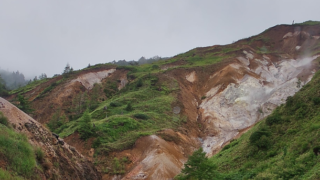
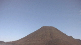
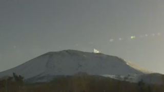
  • Mt. Asama and Mt. Kusatsumotoshirane | Tone River Sabo Office
  • Tone River |  Tone River and Watarase River | Tone River Upstream River Office
  • Gunma Prefectural Roads | Gunma Prefecture Camera Map | Gunma Prefecture Prefectural Land Development Department Road Management Division
  • Mt. Asama and Mt. Shirane, address: Tone River Water System Sabo (Erosion Control) Office, 121-1 Shibukawa, Shibukawa-shi, Gunma 377-8566, camera titles from the top: #1 The East of Mt. Asama Live View, address: Kita Karuizawa, Naganohara-machi, Azuma-gun, Gunma, #2 The West of Mt. Asama, address: Tashiro, Tsumagoi-mura, Azuma-gun, Gunma, #3 Kusatsu Shiranesan (Mt. Shirane) Live View, address: Ainemine, Kusatsu, Kusatsu-machi, Azuma-gun, Gunma

Gunma Prefecture Tourism Information

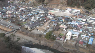
Gunma Prefecture is in contact with Fukushima Prefecture and Niigata Prefecture in the north, Tochigi Prefecture in the east, Saitama Prefecture in the south, Nagano Prefecture in the west. The area of the prefectural land is ​​6,362 square kilometers. The northern prefecture and the western prefecture are mountainous areas, the southern part is a part of the Kanto Plain, and two thirds of the prefectural land is hilly. Since the shape of the prefectural land looks like a crane, it is called “Gunma Prefecture, the form of dancing crane”. Terrain and climate are different in the north and the south, the south is one of Japan’s leading heat wave regions, and the north cool is a cool region with harsh cold winter.
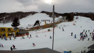
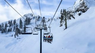
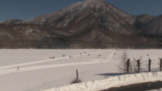
Most of the regions in the northern prefecture are specified in the heavy snowfall, and Katashina village of Tone-gun is specified in the special heavy snowfall. Katashina village, Minakami Village of Tone-gun and Agatsuma County Region in the north have lots of ski resorts because of often snow.

The prefectural population is about 2 million people and the population of the prefectural capital, Maebashi City, is about 340,000 people.

The prefecture name is derived from the prefectural capital, Gunma County, and Gunma means the rich land where horse herd. Gunma is called “Joshu” or “Jomo”, and it comes from the former Ueno County. Ueno County became Takasaki Prefecture after the domain system was abolished, and finally eight provinces were integrated and renamed Gunma Prefecture.

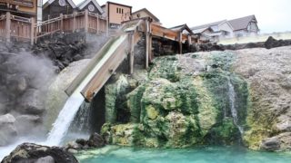
In addition, Gunma is the hot spring kingdom with more than 100 hot springs in the prefecture and there is are famous hot springs such as “Kusatsu Onsen”, “Ikaho Onsen”, “Minakami Onsen” and “Shima Onsen”. “Kusatsu Onsen” is a natural hot spring of water flowing directly from the hot spring source whose natural amount of discharge is the most in Japan. “Ikaho Onsen” has the town of stone steps that is full of emotion. “Minakami Onsen” is characterized by the beautiful valley of the Tone River upstream, “Shima Onsen” is popular because it is said to be the therapeutic bath that works in forty thousand diseases, and these places are high quality and rich natural hot spring areas.

There are local cuisines such as “Okkirikomi”, noodle dishes that homemade wide noodles of wheat flour and seasonal vegetables are stewed, “Namaimokonnyaku Ryori”, which is made from elephant foot, “Yakimanju (baked bun)”, the baked seamed buns that are stabed to bamboo skewers with sweet miso sauce.

error:Content is protected !!