Toyama Prefecture Live Cameras
Toyama Prefecture Eastern (Toyama)
Toyama City | Uozu City | Namerikawa City | Kurobe City | Funahashi Village | Kamiichi Town | Tateyama Town | Nyuzen Town | Asahi Town
Toyama Prefecture Western (Fushiki)
Takaoka City | Himi City | Tonami City | Oyabe City | Nanto City | Imizu City
All over the prefecture
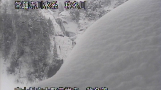
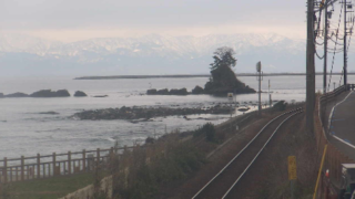
- Kurobe River Basin / Coast / River / Dam / Sabo Area, Image of Observation Point and Water Level and Rainfall / Kurobe River Office Disaster Prevention Information System
- All over Toyama Prefecture / “Disaster Prevention Net Toyama” Oyabe River, Sho River, Jinzu River, Joganji River / Toyama River National Highway Office
- Prefectural roads / National highways in the jurisdiction (National highways 8, 41, 156, 160, Noetsu Expressway / National highway 470) / Toyama River National Highway Office
- Toyama Prefectural Road / Toyama Prefectural Road Situation Live Broadcast / Toyama River National Highway Office
- Prefectural Road / “Toyama Prefecture Snow Michi Network” / Toyama River National Highway Office
- Prefectural Roads / “Toyama Prefecture Winter Road Information” / Toyama Prefecture Civil Engineering Department Road Division
- Noetsu Expressway / Noetsu Expressway Live Camera / Toyama Prefectural Road Corporation
- Throughout Toyama, camera titles: Prefecture west area, Prefecture in western North area, Prefecture center area, Prefecture eastern area, Tateyama, Hida, site title: Disaster prevention net Toyama, National Highway and River Office in Toyama
- Toyama Prefectural Road, camera title: Toyama Prefecture Road Conditions Live, site title: Pallet Toyama Official Website, Toyama River and National Highway Construction Office
- Snow-covered Roads in Toyama Prefecture, camera title: Toyama Snow-covered Road Network, site title: Toyama Office of River and National Highway
- Roads in Toyama Prefecture, camera title: Toyama prefecture winter road information, site title: Toyama Prefecture Civil Engineering Department Road Division
- Kurobe River basin, camera titles: Sabo dam rivers and coastal areas, water level and rainfall images and observation point, site title: Kurobe River Office Disaster Information System
- Throughout the Northern Alps, URL: http://www.alps-kanko.jp/, camera titles: Azusa River, Norikura Kogen, Azumi, Kamikochi, site title: Alps mountain Township
- Rivers and Roads in Toyama, site title: Toyama Office of River and National Highway
Toyama Prefecture Tourism Information
The prefectural capital is Toyama City. The prefecture population is about 1.08 million people. Once it was called “Ecchu Province”. It is known as an area of heavy snowfall, and it is famous for “Tateyama mountain range”, “Tateyama Kurobe Alpine Route” and “Shirakawa-go”. It is the nation’s leading rice producer, and tulip, dried persimmons and jumbo watermelon are also known as specialty products. There are some local cuisines such as “Masuzushi,” the pressed sushi that seasoned the trout in vinegar, and “Buri-daikon (Yellowtail Japanese radish),” discarded portions of buri (yellowtail) that are boiled with soy sauce together with daikon (Japanese radish).
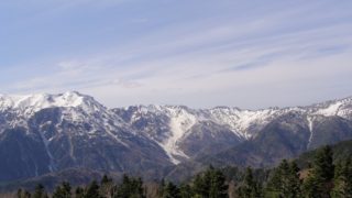
“Tateyama” refers to the three mountains, Oyama, Onanjiyama and Fuji-no-oritate, and the mountain that is called “Tateyama” does not exist. Any mountain of the the three is an altitude of 3,000m class mountain, and it is only Tateyama where there is glacier in Japan.
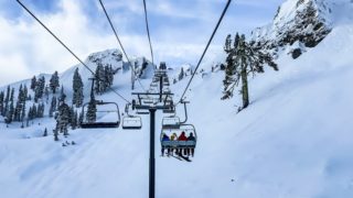
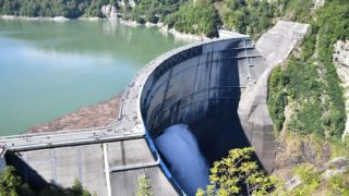
“Tateyama Kurobe Alpine Route” is the mountain tourist route connecting the Ogizawa Station of Nagano Prefecture and Tateyama Station of Toyama Prefecture, which was opened in 1971. One million people of tourists visit in every year. Using cable car, bus and the ropeway, you can cross the border. The straight-line distance between the stations is about 25km, but Tateyama Station is at an altitude of 475m and Murodo Station is at an altitude of 2,450m, and it it the root of the height difference of about 2km. In the middle of the route there is the “Kurobe Dam”, the majestic scenery and the discharge from the dam from June to October of each year have become tourist specialties. “Kurobe Dam” was completed over the years from 1956 seven years. The length of the dam is 492m and the height of 186m is the highest in Japan, and the total storage capacity is 200 million cubic meters. You can enjoy superb views of the huge Kurobe Dam, Tateyama mountain range and the Northern Alps from the observatory at an altitude of 1500m.
In addition, “Snow Otani” appears in the Alpine route from April to June every year. The Alpine route is opened by shoveling snow in the heavy snowfall area, but the walls of snow made by the snow removal is the height of 20m in snowy year. In “Snow Otani, “the walls of the huge snow, you can not only take a bus, but you can also walk in the limited time of the event, “Snow Otani walk”. Rather than passing quickly by bus, you can walk the Murodo of altitude 2450m while feeling the big wall of snow.