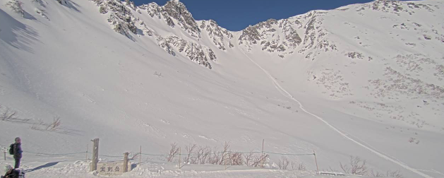
This is a live camera installed at Hotel Senjojiki (altitude 2,612m) in Ako, Komagane City, Nagano Prefecture, in the Central Alps. It shows real-time footage of Senjojiki Crique, the ropeway, and the Southern Alps panorama. Hotel Senjojiki, located at the summit station of the Komagatake Ropeway, is the highest-altitude hotel in Japan. The camera streams 365 days a year, 24 hours a day.
Senjojiki Crique is a glacial landform (cirque) created approximately 20,000 years ago during the Ice Age, when glaciers carved a bowl-shaped depression into the bedrock. It spreads directly below Mt. Hokenzan (Hōken-dake, altitude 2,931m) in the Central Alps. In summer (mid-July to late August), it becomes a flower garden filled with alpine plants in bloom; in autumn (late September to mid-October), it is renowned for its spectacular fall foliage, attracting many hikers and tourists. In winter, the area is blanketed in snow and the live camera is useful for checking snow conditions.
To reach Senjojiki Crique, take the Komagatake Ropeway (Sugenodai Bus Center → Shirabidaira → Senjojiki). You can also check the weather forecast, rain cloud radar, and map below.
- Watch Live Camera
- Live Camera Information
- Basic Information about Senjojiki Crique
- Seasonal Highlights & Live Camera Usage Guide
- Komagatake Ropeway & Access Information
- Weather Forecast and Expected Temperature in Komagane City, Nagano Prefecture
- Rain Cloud Radar in Komagane City, Nagano Prefecture
- Map of Ako, Komagane City, Nagano Prefecture (Google Maps)
- Senjojiki Crique Related Videos
- Nearby Live Cameras
Watch Live Camera
Live Camera Information
- Distribution type – Still image
- Streaming period – 365 days / 24 hours
- Distribution/Management – Chuo Alps Komagatake Ropeway
- Location – Central Alps Hotel Senjojiki (Japan’s highest-altitude hotel), 1 Ako, Komagane City, Nagano, 399-4117
- Related site – WeatherNews “Senjojiki Crique Autumn Foliage Information”
Basic Information about Senjojiki Crique
Senjojiki Crique is a glacial landform located within Chuo Alps Quasi-National Park in southern Nagano Prefecture. The floor of the cirque sits at approximately 2,612m elevation, with Mt. Hokenzan (Hōken-dake) towering above at 2,931m. It was formed about 20,000 years ago during the last Ice Age, when glaciers carved a bowl-shaped depression into the bedrock — a landform known as a “cirque.” The name “Senjojiki” (千畳敷) derives from the fact that it is wide enough to lay out a thousand tatami mats. A walking trail of approximately 40 minutes loops through the cirque, allowing visitors to enjoy alpine flora and dramatic rocky cliffs.
You can also check the live camera for Mt. Komagatake in the Central Alps, located approximately 1.9 km away.
Seasonal Highlights & Live Camera Usage Guide
- [Spring] Remaining snow and blue skies (May–June): Ropeway operation start season
- [Summer] Alpine flower garden (mid-July – late August): Veratrum album (Koba-ikeiso), Dryas (Chinguruma), and more
- [Autumn] Fall foliage (late September – mid-October): Guide to peak viewing period
- [Winter] Snow scenery / snowfall check (November–): Use the camera to monitor snowpack and road conditions
Komagatake Ropeway & Access Information
To access Senjojiki Crique, take the Komagatake Ropeway. From Sugenodai Bus Center, take a bus to Shirabidaira Station, then ride the ropeway to Senjojiki Station — about 7 minutes 30 seconds. Senjojiki Station, at 2,612m, is the highest ropeway station in Japan. During peak seasons (mainly summer and autumn), private vehicle access is restricted, and a bus from Sugenodai Bus Center is required. For ropeway operating hours and fares, please check the official website of Chuo Alps Komagatake Ropeway.
Weather Forecast and Expected Temperature in Komagane City, Nagano Prefecture
Rain Cloud Radar in Komagane City, Nagano Prefecture
Map of Ako, Komagane City, Nagano Prefecture (Google Maps)
- View Google Maps