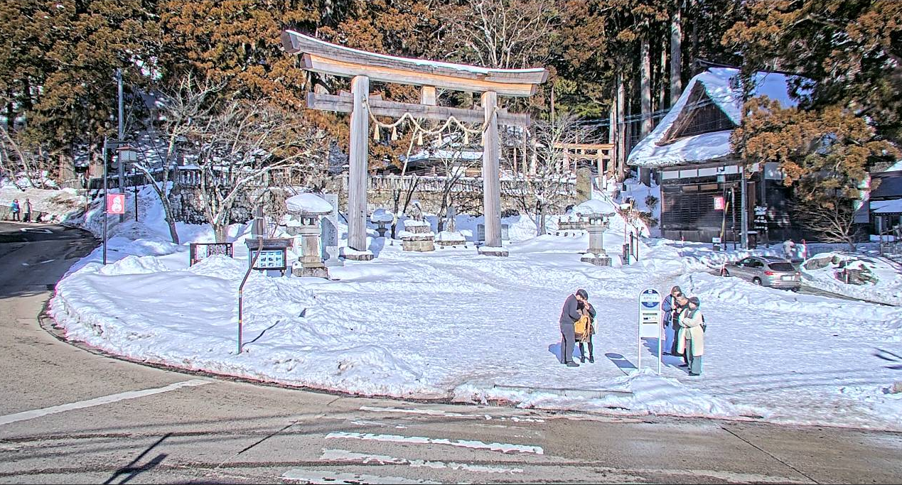
Togakushi Shrine, Kagami Pond, Campsite Live Camera | Nagano City, Nagano Prefecture

Togakushi Shrine Nagano-shi
sample image
Advertisements

This page shows live camera images from Togakushi Kogen in Nagano City, Nagano Prefecture. The cameras cover five locations: Togakushi Shrine Chusha courtyard, Togakushi Kagamiike Pond, Togakushi Campsite, the entrance to the Togakushi Shrine Okusha approach, and the entrance to Togakushi Shrine Hokosha. These still-image live cameras are operated by the Togakushi Tourism Association and update every 10 minutes, making it easy to check current snow, autumn leaves, weather, and local conditions from home.

Togakushi Kogen sits at an elevation of about 1,200 meters. It is one of northern Nagano City’s representative sightseeing areas, with fresh greenery in spring, cool highland weather in summer, autumn foliage, and snowy scenery in winter. Whether you are planning a drive, hike, camping trip, shrine visit, or soba tour, these cameras are useful for checking road and weather conditions before departure.

Togakushi Shrine Hokosha
Togakushi Kagamiike Pond
Togakushi Campsite
Togakushi Campsite
Advertisements

Watch Live Camera

Live Camera Information

Live Camera Locations

  • Togakushi Shrine Chusha courtyard
  • Togakushi Kagamiike Pond
  • Togakushi Campsite
  • Entrance to the Togakushi Shrine Okusha approach
  • Entrance to Togakushi Shrine Hokosha
Advertisements

What Each Camera Shows

The five cameras operated by the Togakushi Tourism Association show different parts of the Togakushi area.

1. Togakushi Shrine Chusha courtyard camera: This camera shows the front approach and courtyard of Togakushi Shrine Chusha. It is filmed from the roof of the tourist information center and is useful for checking visitor crowds and road surface conditions. Please note that the road in the lower part of the image has snow-melting equipment, so use care when judging overall snow depth.

2. Togakushi Kagamiike Pond camera: This camera shows Kagamiike Pond from Kagamiike Donguri House. Located at about 1,200 meters above sea level, the pond is famous for reflecting the Togakushi mountain range on its surface. It is especially beautiful during the autumn foliage season from early to mid-October, and the camera is useful for checking the progress of the colors.

3. Togakushi Campsite camera: This camera shows the campsite from the ranch management office. Togakushi Campsite is one of Japan’s largest free campsites, covering about 22.5 hectares, with the Togakushi mountain range as a backdrop. Use it to check weather and crowd conditions before check-in.

4. Togakushi Shrine Okusha approach entrance camera: This camera shows the entrance to the Okusha approach. It lets you check the cedar avenue and trail surface conditions, which is especially helpful before winter trekking.

5. Togakushi Shrine Hokosha entrance camera: This camera is installed beside the stairs at the Hokosha parking area. It shows the entrance area just after coming in from Bird Line, Prefectural Route 36, and can be used as a guide to parking congestion.

Togakushi Seasonal Highlights and Snow Calendar

Because Togakushi Kogen is located at about 1,200 meters above sea level, the seasons arrive earlier than in lowland areas, and the region receives heavy snow in winter. Use the live cameras together with the calendar below when planning your visit.

SeasonHighlights and Notes
April to MayRemaining snow and fresh greenery appear together. New growth usually begins around Golden Week.
June to JulyCool highland summer. Some areas have fireflies, and the climate is ideal for escaping the heat.
AugustPeak season for camping and hiking. Weekends can be very crowded.
Late September to mid-OctoberAutumn foliage season. Kagamiike Pond is usually best from early to mid-October. Check the camera before visiting.
November to MarchSnow season. Togakushi Ski Resort usually opens in early December. Check live cameras and road cameras for snow and icy road conditions.

For winter visits, search for the latest Togakushi snow and road condition information before departure. Prefectural Route 36, also known as Bird Line, may have chain restrictions or closures during winter weather.

Advertisements

Access and Parking for Togakushi Kogen

By train and bus: From JR Nagano Station, use the Zenkoji Exit bus terminal and take the Nagaden Bus Togakushi Kogen Line. It takes about 70 minutes to reach Chusha, near Togakushi Shrine Chusha. Bus frequency changes by season, so check the Nagaden Bus timetable in advance.

By car: From Nagano IC on the Joshinetsu Expressway, it takes about 40 to 50 minutes via National Route 406 and Prefectural Route 36, Bird Line. On weekends during the autumn foliage season from early to mid-October, roads around Togakushi can be heavily congested. Check the live cameras and consider departing early in the morning.

Parking guide:

  • Okusha: Free parking is available in front of the Okusha approach entrance, about 200 spaces.
  • Chusha: Free parking at the west approach entrance, about 20 spaces, plus west-side free parking and paid parking.
  • Hokosha: Free parking is available after turning from Bird Line.
  • Kagamiike Pond: Use the parking area in front of Kagamiike Donguri House.

During autumn foliage season, Golden Week, and the Obon holiday period, parking lots often fill up. Please avoid parking on surrounding roads.

Other Live Cameras in the Togakushi Area

There are other live cameras in the Togakushi area in addition to the tourism association cameras. Use them according to your purpose.

  • Togakushi Ski Resort live camera – Check slope conditions, lift operation, and snow depth from December to March.
  • Hokosha / Prefectural Route 36 live camera – Check road surface, snow, and traffic conditions on Bird Line.
  • Nagano City live camera list – Check tourism, road, and river cameras across Nagano City.
Advertisements

Weather in Nagano City, Nagano Prefecture

Rain Cloud Radar in Nagano City, Nagano Prefecture

雨雲レーダー - Yahoo!天気・災害
全国各地の実況雨雲の動きをリアルタイムでチェックできます。地図上で目的エリアまで簡単ズーム!
Advertisements

Weather Forecast for Nagano Prefecture

Map of Nagano City, Nagano Prefecture (Google Maps)

  • View Google Maps

Related Videos of Togakushi Shrine

You cannot copy content of this page