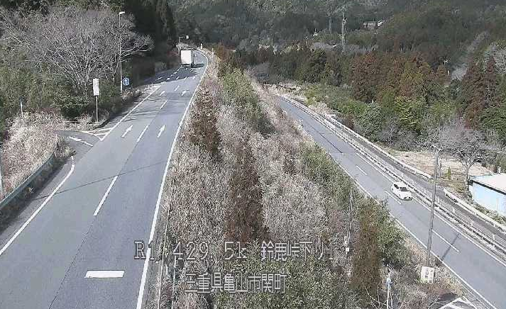
This page lets you check live camera images from National Route 1 at Suzuka Toge Pass in Sekicho, Kameyama City, Mie Prefecture. The road monitoring cameras are managed and distributed by the Mie River and National Highway Office.
The cameras cover more than 23 points, including the northern part of Suzuka Pass, with 6 uphill and 9 downhill locations; the southern part of Suzuka Pass, with 2 uphill and 4 downhill locations; Kutsukake Intersection; Kutsukake Pedestrian Bridge; Nakatsu Bridge; Ichinose Bridge; Roadside Station Sekijuku; Onogawa Bridge; and Taiokaji Temple. The images are still images that update automatically about every 15 minutes.
Suzuka Toge Pass is a mountain section of about 4.6 km that connects Mie and Shiga prefectures. In winter, snow and icy road surfaces often make driving conditions worse. Preventive road closures may be implemented during heavy snow, so checking the current road surface and snow conditions on the live cameras before driving is recommended. The route is also often used as a detour when the Meihan National Highway or Shin-Meishin Expressway is closed, making it useful for checking congestion in advance.
- Watch Live Camera
- Live Camera Information
- Snow, Road Closure, and Detour Information for Suzuka Pass
- How to Read the Suzuka Pass Live Cameras
- Access and Road Information Around Suzuka Pass
- Weather in Kameyama, Mie
- Rain Cloud Radar in Kameyama, Mie
- Mie Prefecture Weather Forecast
- Map of Kameyama, Mie (Google Maps)
- Nearby Live Cameras
Watch Live Camera
Live Camera Information
- Streaming type – Still image
- Update interval – 15 minutes
- Provider/management – Mie River and National Highway Office
- Installation locations – Northern Suzuka Pass, 9 downhill and 6 uphill locations; Southern Suzuka Pass, 4 downhill and 2 uphill locations; Kutsukake Intersection; and other Suzuka Pass locations including Kutsukake Pedestrian Bridge, Nakatsu Bridge, Ichinose Bridge, Roadside Station Sekijuku, Onogawa Bridge, and Taiokaji Temple
- Image source – Created by processing content from the Mie River and National Highway Office website
Snow, Road Closure, and Detour Information for Suzuka Pass
On National Route 1 at Suzuka Toge Pass, between Kutsukake in Sekicho, Kameyama City and Yamanaka in Tsuchiyama-cho, Koka City, Shiga Prefecture, preventive road closures may be carried out when heavy snow is expected. If a closure is implemented, vehicles passing through Suzuka Pass are directed to a detour at the Tokaido Sekijuku East Intersection in Sekicho Kizaki, Kameyama City. Local residents may still be allowed to pass depending on the closure details.
As a general detour, the Shin-Meishin Expressway between Kameyama JCT and Koka-Tsuchiyama IC, or the Meihan National Highway, National Route 25, are the main alternate routes. However, there are cases where both the Meihan National Highway and Shin-Meishin Expressway are closed at the same time, so be sure to check the latest restrictions on road information sites and the Ministry of Land, Infrastructure, Transport and Tourism Mie River and National Highway Office X account, @mlit_mie, before departure.
During winter, especially from around December to February, crossing the pass on normal tires is dangerous. Winter tires or tire chains are strongly recommended.
How to Read the Suzuka Pass Live Cameras
The live camera images introduced on this page are distributed and managed by the Mie River and National Highway Office of the Chubu Regional Development Bureau, Ministry of Land, Infrastructure, Transport and Tourism.
They are still images that update at regular intervals, about every 15 minutes. The cameras monitor road surfaces, traffic, and weather conditions along National Route 1, including the Tokaido and Suzuka Pass Bypass sections.
Because of the update timing, the displayed camera image may differ slightly from the actual current road surface conditions. In particular, during sudden weather changes in winter, road conditions may change significantly before the next image update. Check the official MLIT website and X account together with the live camera images for the latest restriction information. If an old image appears in your browser, try reloading the page.
Access and Road Information Around Suzuka Pass
Suzuka Pass is an old Tokaido pass route connecting Sekicho, Kameyama City in Mie Prefecture with Tsuchiyama-cho, Koka City in Shiga Prefecture. Today it is maintained as National Route 1, including the Suzuka Pass Bypass. Located on the border between Mie and Shiga, it is used by many drivers as a general road route between the Nagoya area and the Osaka/Kyoto area.
If using expressways, the Shin-Meishin Expressway between Kameyama JCT and Koka-Tsuchiyama IC runs nearby and can be an effective alternative during bad weather. The route between Kameyama IC and Seki IC via the Meihan National Highway, National Route 25, is also an option.
Live cameras around the Suzuka Tunnel section of National Route 1, near the 433.7 km post in Tsuchiyama-cho, Koka City, Shiga Prefecture, can also be checked on related pages. For nearby cameras, see the related live camera information as well.
Weather in Kameyama, Mie
Rain Cloud Radar in Kameyama, Mie
Mie Prefecture Weather Forecast
Map of Kameyama, Mie (Google Maps)
- View Google Maps