Hiroshima Prefecture Live Cameras
Hiroshima Prefecture Southern part (Hiroshima)
Hiroshima City | Kure City | Takehara City | Mihara City | Onomichi City | Fukuyama City | Fuchu City | Otake City | Higashi Hiroshima City | Hatsukaichi City | Etajima City | Fuchu Town | Kaita Town | Kumano Town | Saka Town | Osakikamijima Town | Sera Town | Jinsekikogen Town
Hiroshima Prefecture Northern part (Shobara)
Miyoshi City | Shobara City | Akitakata City | Akiota Town | Kitahiroshima Town
All over the prefecture
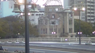
- Atomic Bomb Dome and Hiroshima Peace Memorial Park | Naka Ward, Hiroshima City, Hiroshima Prefecture | Mix Co., Ltd., Hiroshima Television / Hiroshima Television On Demand
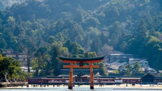
- Itsukushima Shrine | Miyajimacho, Hatsukaichi City, Hiroshima Prefecture | Miyajima Tourism Association, Hirotele!NEWS and Hiroshima Home Television
- Miyajima Omotesando shopping street | TOTO Miyajima Omotenashi public restroom, 536-1 Miyajima-cho, Hatsukaichi City, Hiroshima Prefecture 739-0588 | Miyajima Tourism Association
- Hiroshima Station | Sheraton Grand Hiroshima Hotel, 12-1 Wakakusa-cho, Higashi-ku, Hiroshima-shi, Hiroshima 732-0053 | Hiroshima Home TV
- Hiroshima Airport | Hiroshima Airport, 64-31 Hongocho Zennyuji, Mihara, Hiroshima 729-0416 | Hiroshima Airport Promotion Council
- Miyoshi Takataniyama Cloud Sea | Mt. Takatani Observatory, Awayamachi, Miyoshi City, Hiroshima | Net A-Shukou
- Bingo Tojo no Sato | Tojo-cho, Shobara City, Hiroshima
- Nihohime Jinja Shrine | Nihohime Jinja Shrine, 12-17 Nishihonura-cho, Minami-ku, Hiroshima-shi, Hiroshima 734-0045
- Kotokuji Temple | Kotokuji, 1386 Teramachi, Sera-machi, Sera-gun, Hiroshima 722-1111
- Onomichi Expressway | “Onomichi Expressway” Miyoshi East JCT / IC, Mirasaka Tunnel North Wellhead, Mirasaka IC, Kisa IC, Uga Pass Bridge, Rokusogawa Bridge, Ugagawa Bridge, Betsusako Tunnel South Wellhead, Sera IC, Uzuto Daiichi Iwane Tunnel North Wellhead, Iwane Tunnel South Wellhead, Onomichi North IC, Kinosho Tunnel North Wellhead | Mirasaka National Highway Office
- Ota River and Oze River | Ota River Water System, Oze River Water System | Ota River Office
- Roads in Hiroshima Prefecture | camera title: Road Information and Winter Road Information – National highways 182, 183, 186, 191, 261, 314, 432, 433, etc. | site title: Road Disaster Prevention Information System, Hiroshima Road Navi
- Ondo-no-Seto North Exit / Ondo-no-Seto South Exit 1 / Ondo-no-Seto South Exit 2 | Kure City, Hiroshima | Japan Coast Guard
- Takehara Port | Takehara Port, 4-2 Minatomachi, Takehara City, Hiroshima Prefecture 725-0024 | LIVECAM TAKEHARAPORT TADANOUMIPORT JAPAN
Hiroshima Prefecture Tourism Information
The prefectural capital of Hiroshima is Hiroshima City. The population of the prefecture is approximately 2.8 million people and the population of the city is about 1.2 million people. Facing the Seto Inland Sea, the prefectural land has more than 140 large and small islands.
There are two world cultural heritages sites, Itsukushima Shrine and Hiroshima Peace Memorial (Atomic Bomb Dome). There are tourism resources such as Hiroshima-jo Castle, Tomo-no-Ura, Ondo-no-Seto, Sandan-kyo, Taishaku-kyo and Onbashi Bridge, Higashi Hiroshima Brewery Street and others.
Itsukushima Shrine in Miyajima-cho of Hatsukaichi City was built in the year 593 AD, and it had been assisted by those in power at the time, such as Hideyoshi Toyotomi, Kiyomori Tairano and Motonari Mori later. It is an unusual architectural style shrine in the world that is built on top of the sea and the torii (a gateway at the entrance to a shrine) of 16m high was also erected on top of sea. Since the shrine of Shindenzukuri style was built by Kiyomori Tairano in 1168, it was repaired repeatedly many times, and it still remains with the architectural style of the time.
It is said that the origin of “Hiroshima” is that it was named by Terumoto Mori who had dominated “the Aki country” and “the country Bingo” in the Warring States Period.
There are some specialty and specialty products, such as Okonomiyaki, Oyster, Momiji Manju (Autumn Leaves Bun), Hiroshima-na (Hiroshima Greens), Kumano Fude (Brush) and Onomichi Ramen.
Especially, oyster is a major specialty of Hiroshima and has a history of over 400 years of farming, which boasts a 70% market share in the nation. There are local cuisines such as Hiroshima-style Okonomiyaki (Japanese hot plate pizza), Anago-meshi (Conger Rice), Kaki-no-Dotenabe (oyster and vegetable stew with miso).
More than three million tourists annually visit Miyajima where the Itsukushima Shrine exists.
Tomo-no-Ura refers to the port area in Tomo-cho in Fukuyama City, and it has been developed as a port of Shiomachi (waiting for the tide). It has been developed as a port of call sites to wait the trend of the tide is reversed at the time when there is not the ship with the steam engine power yet. It was also important as a strategic point for marine traffic in the Warring States Period, but its importance gradually faded with the development of nautical technology. It was designated as a national scenic spot in 1925, and it has now become a tourist attraction as the city of port in which the streets and the port facilities of the time remain.
Tomo-no-Ura is also famous as the place where Ryoma Sakamoto stayed in Iroha Maru incident (the incident of the ship Irohamaru). The Iroha-maru Ship Incident is the case that the ship of Kaientai, which Ryoma Sakamoto belonged to, collided with the ship of Kishu-han (Kishu Clan), and he stayed in Tomonoura for compensation negotiations. There is the Iroha-maru Ship Memorial in Tomonoura that displays the documentations of the time and there is the residence of Masuya Seiemon where Ryoma stayed.
Ondo-no-Seto is a strait between Kegoya in Kure City and the town of Ondo, the strait of small width 90m. Despite it is actually the narrow strait that there is only about 60m navigable width, there is a daily traffic volume of about 700 vessels today. There is the tradition that it was carved out in 1167 by Kiyomori Tairano, and the statue of Kiyomori is displayed in the park Ondo no Seto.