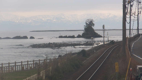
This is a live camera installed on the Amaharashi Coast in the northern part of Takaoka City, Toyama Prefecture. From Amaharashi Coast, you can see Toyama Bay, Onnaiwa, Otokoiwa, Yoshitsune Shrine, Yoshitsune Iwa, National Route 415, and if the weather is good, you can see the Northern Alps and the Tateyama Mountain Range beyond Toyama Bay in the distance. Distributed by Amaharu Tourism Association and Roadside Station Amaharashi.
Amaharashi Beach is located within the Noto Peninsula Quasi-National Park and has been selected as one of Japan’s 100 Best Beaches and 100 Best White Sand and Green Pines. Onnaiwa, located off the coast of Amaharashi Coast, is a rock with an area of approximately 400m and a circumference of 80m.It is said that it was named Onnaiwa because the scenery with the surrounding reef resembles a mother and child.
You can also check the weather forecast, rain cloud radar and map.
watch live camera
Live camera information
- Distribution type – video
- Distribution/Management – ① Amaharu Tourism Association ② Roadside Station Amaharashi
- Installation location – ① Amaharashi Coast, Ota, Takaoka City, Toyama Prefecture, 933-0133 ② Roadside Station Amaharashi, 24-74 Ota, Takaoka City, Toyama Prefecture, 933-0133
Weather in Takaoka City, Toyama Prefecture
Rain cloud radar in Takaoka City, Toyama Prefecture

Toyama Prefecture weather forecast
Map of Ota, Takaoka City, Toyama Prefecture (Google Maps)
- View Google Maps
- View street view