Aichi Prefecture Live Cameras
Aichi Prefecture Western (Nagoya)
Nagoya City | Okazaki City | Ichinomiya City | Seto City | Handa City | Kasugai City | Tsushima City | Hekinan City | Kariya City | Toyota City | Anjo City | Nishio City | Inuyama City | Tokoname City | Konan City | Komaki City | Inazawa City | Tokai City | Obu City | Chita City | Chiryu City | Owariasahi City | Takahama City | Iwakura City | Toyoake City | Nisshin City | Aisai City | Kiyosu City | Kitanagoya City | Yatomi City | Miyoshi City | Ama City | Nagakute City | Togo Town | Toyoyama Town | Oguchi Town | Fuso Town | Oharu Town | Kanie Town | Asuka Town | Agui Town | Higashiura Town | Minamichita Town | Mihama Town | Taketoyo Town | Kota Town
Aichi Prefecture Eastern (Toyohashi)
Toyohashi City | Toyokawa City | Gamagori City | Shinshiro City | Tahara City | Shitara Town | Toei Town | Toyone Village
All over the prefecture
- Inuyama Castle | Inuyama Castle, 65-2 Inuyama Kitakoken, Inuyama City, Aichi Prefecture 484-0082 | National Treasure Inuyama Castle & Live with a View of Mitake
- Inuyama Castle and Kiso River | Unumaminami, Kagamihara City | Ministry of Land, Infrastructure, Transport and Tourism
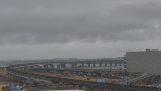
- Nagoya Airport | Nagoya Airfield (prefectural Nagoya Airport), Toyoba, Toyoyama-cho, Nishikasugai-gun, Aichi 480-0202
- Chausuyama Plateau | Toyone Village, Kitashitara District, Aichi Prefecture | Chausuyama Highlands
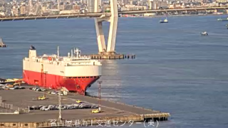
- Ise Bay, Ise Bay Vessel Traffic Service Center | Irago Town, Tahara City, Aichi Prefecture | Japan Coast Guard
- Nagoya Sakae, Nagoya Station, Gifu City, Tsu City | Nagoya TV News Channel
- Shonai River | Information on water level and rainfall in the Shonai River basin, surveillance camera | Shonai River Office
- Yahagi River, Toyogawa, Ure River, Toyogawa Floodway | River Disaster Prevention Information | Toyohashi River Office, Chubu Regional Development Bureau, Ministry of Land, Infrastructure, Transport and Tourism
- Prefectural Rivers | “Kiso river upstream river office live camera image” Kiso river, Nagara river, Ibi river, Makida river, Neo river, Kiso river dam | Ministry of Land, Infrastructure, Transport and Tourism Kiso river upstream river office
- Kiso River | Tokai Bridge, Aisai City, Aichi Prefecture, Tatsuta Bridge, etc. | Kiso River Downstream River Office, Chubu Regional Development Bureau, Ministry of Land, Infrastructure, Transport and Tourism
- Prefectural Rivers | “Disaster prevention information for Aichi rivers ” Shinkawa / Tenshiro river / Nikko river, Sakai river / Azuma river | Aichi prefecture construction department river section
- Ise Bay / Mikawa Bay | Nagoya Port Maritime Transportation Center, Nagoya Port Garden Pier, Hashida Nose Lighthouse | Coastal Area Information System Nagoya Coast Guard
- Prefectural Roads / Rivers / Sea | “Katch Live Camera” Roads – Azuma Town, Anjo City (National Road No. 1), Imamoto Town, Anjo City (National Road No. 1), Kariya PA (Ise Bay Coast Road), Imagawa Town, Kariya City (National Road No. 23) ), Kariya City Noda Town (National Highway No. 23), Nishio City Yatsumen Town (National Highway No. 23), Takahama City Bikai Town (Kinuura Ohashi), Henan City Minato Honmachi (National Highway No. 247), Anjo City Kakibashi Town (City Road No. 40) Kariya Station Noda Town, Kariya City (R23), Sea / River – Showa, Kariya City (Saruto River), Takasu Town, Kariya City (Saruto River), Izumida Town, Kariya City (Sakai River), Azuma Town, Kariya City (Azuma River), Yonezu Bridge Nishio City (Yahagi River), Okazaki Ohashi Okazaki City (Yahagi River), Anjo City Kakibashi Town (Kanda Branch River), Anjo City Jonan Town (Otada River), Anjo City Akamatsu Town (Hanba River), Kira Town, Nishio City (Miyazaki Coast), Minato Honmachi, Anjo City (Kariura Port) | Katch Network Co., Ltd.
- Rivers in Aichi Prefecture, camera title: Aichi prefecture river surveillance camera, site title: Aichi Prefecture Construction Division River Division
- Central Nippon Expressway jurisdiction road, camera titles: Tomei, Shin-Tomei, Chuo Expressway, Meishin Expressway, Shin-Meishin Expressway, Hokuriku Expressway, Tokai Hokuriku Expressway, Maizuru Wakasa Road, Odawara Atsugi Road, Ken-O Expressway, site title: Central Nippon Expressway Company Limited
Aichi Prefecture Tourism Information
The prefectural capital is Nagoya City. The population of the prefecture is about 7.4 million people, and the population of Nagoya City is about 2.2 million people. It was the former Owari Country and Mikawa Country. The prefectural land is 106km from east to west and 94km from north to south, and the area of the prefectural land is 5,163 square km, and 42% of the land is forest. It is the land that produced the warlords such as Oda Nobunaga, Toyotomi Hideyoshi and Tokugawa Ieyasu.
There are a number of large companies, including Toyota, and it is the industrial prefecture that has been the national first place for many years in product shipments.
The specialty products of the prefecture are Uiro (sweet rice jelly), Kishimen (flat wheat noodles), Miso-katsu (pork cutlets with miso sauce), Hatcho-miso, Moriguchi-duke (pickles) and Ebi Senbei (shrimp crackers).
The local cuisines include Hitsumabushi, which is mixed with rice and minced grilled eel, and Misonikomiudon (wheat flour noodles with miso soup), wehat flour noodles in soup of Hatcho miso with small pieces of bonito.
There are tourist attractions such as Nagoya Castle, Atsuta Shrine, Inuyama Castle, Kiyosu Castle, Port of Nagoya Public Aquarium, Meiji Village, Toyota Automobile Museum, Japan Monkey Park, Central Japan International Airport Centrair and so on.
Nagoya Castle was completed in 1612 as a residence of Tokugawa Ieyasu’s son, Yoshinao, and had been used as a residence of the Owari Tokugawa clan until the end of Edo period. A killer whale of gold on top of the tower of Nagoya Castle is said to be a symbol of Nagoya, and it became the etymology of “Shatchokobaru” (Shachihokobaru), which means to take a poised attitude as killer whale or be tense and becomes hard.
Although the current gold killer whale is what was restored, the original one of the time Nagoya Castle was completed used gold for a total of 215kg, which was equivalent to 1,940 oval gold coins of the time, Keicho Ouban, and it was enough effect to notify the world the dashing of the Tokugawa family. The people looked at the gold killer whale that was left on top of the tower of Nagoya Castle, and they felt how the Tokugawa family had wealth and power.
Port of Nagoya is the trade port that ranks first in the nation in total imports and exports, and exports finished cars, most of which are the ones of the Toyota automobile, and auto parts and steel, and imports liquefied natural gas, iron ore and crude oil.
Port of Nagoya Public Aquarium of Nagoya Port Garden Pier is is one of the world’s largest aquarium, which opened in 1992. 500 species and 50,000 marine lives such as Penguin, dolphin, killer whale, beluga, sea turtles, fish are exhibited in the aquarium. South Building has the theme of journey to the South Pole, and exhibites the aquariums of Japan sea, deep sea gallery, the sea of the equator, the Australian waterfront and the sea of Antarctica. North Building exhibites mainly large marine mammals such as dolphins and killer whales on the theme of Distant Journey 3.5 billion years