Okayama Prefecture Live Cameras
Okayama Prefecture Southern (Okayama)
Okayama City | Kurashiki City | Tamano City | Kasaoka City | Ibara City | Soja City | Takahashi City | Bizen City | Setouchi City | Akaiwa City | Asakuchi City | Wake Town | Hayashima Town | Satosho Town | Yakage Town | Kibichuo Town
Okayama Prefecture Northern part (Tsuyama)
Tsuyama City | Niimi City | Maniwa City | Mimasaka City | Shinjo Village | Kagamino Town | Shoo Town | Nagi Town | Nishiawakura Village | Kumenan Town | Misaki Town
All over the prefecture
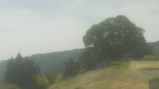
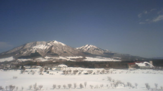
- Hiruzen Sanza | Hiruzen Nishikayabe, Maniwa City, Okayama Prefecture | Maniwa City Office and Internet Nature Institute
- Mikamo Shukuba Zakura | Mikamo Shukuba Cherry Blossom, Mikamo, Maniwa City, Okayama Prefecture 717-0105 | Maniwa City Office
- Daigo Sakura | Daigo Sakura, Bessho, Maniwa City, Okayama Prefecture 719-3157 | Maniwa City Office
- Tsuyama Castle and Kakuzan Park | Tsuyama Castle Ruins Kakuzan Park, 135 Yamashita, Tsuyama City, Okayama Prefecture 708-0022 | Tsuyama City Tourism Association
- Kamba Falls | Kanba, Maniwa City, Okayama Prefecture 717-0004 | Maniwa City Office
- Okayama Airport | Okayama Airport (Momotaro Okayama Airport) , 1277 Nichioji, Kita-ku, Okayama-shi, Okayama 701-1131 | TV Setouchi
- Roadside Station Okutsu Onsen | Roadside Station Okutsu Onsen, 463 Okutsu, Kagamino-cho, Tomata-gun, Okayama 708-0503 | Kagamino Town Official Website
- Lake Onbara | Lake Onbara, Kamisaibara, Kagamino Town, Tomata District, Okayama Prefecture 708-060 | Kagamino Town Office
- Okutsukei | 16-2 Okutsukawanishi, Kagamino Town, Tomata District, Okayama Prefecture 708-0504 | Kagamino Town Office
- Mt. Nagi | Nagi Town Office, 306-1 Toyosawa, Nagi-cho, Katsuta-gun, Okayama 708-1392 | Nagi Town Office
- Tomata Dam / Lake Okutsu (reservoir), near Sugibashi on the Yoshii River, downstream of the dam / Tomata Dam Management Office
- Yubara Onsen / Riverbed around the sand bath of Yubara Onsen / Hiruzen / Daisen Walker
- Okayama Coast / “Okayama Coast Live Camera” Bizen City Nisseicho, Setouchi City Ushimado, Okayama City Kogushi, Tamano City Uno, Kurashiki City Tamano, Asaguchi City Yorishima, Kasaoka City Kasaoka / Okayama Prefecture Crisis Management Division
- Prefectural rivers / Yoshii river, Kongo river, Asahi river, Hyakken river, Takahashi river, Oda river / Okayama river office
- Prefectural rivers / “Okayama prefecture river camera” Takaryo river, Oda river, Bitchu river, Sunagawa river, Yoshii river, Sasagase river, Ashikaga river / Okayama prefecture civil engineering department river section
- Prefectural National Road / Okayama Prefectural Winter Road Meteorological Information System / Okayama Prefectural Civil Engineering Department Road Maintenance Division Maintenance Group
- National highway No. 53, Tottori Expressway , etc./Kuroo tunnel south, Maguwa uphill, Maguwa uphill down, Tenjinbashi north, Tenjinbashi south, Nagi loop bridge, Nagi loop bridge south, Nagi tunnel north, near National highway No. 53 Kuroyama Pass / Ministry of Land, Infrastructure, Transport and Tourism China Regional Development Bureau Okayama National Highway Office
- Rivers in Okayama, camera titles: Yoshii-gawa, Kongou-gawa, Asahi-kawa, Takahashi-gawa, Oda-gawa, Onoda-gawa, address: Okayama River Office, 2-4-36 Shikada-cho, Kita-ku, Okayama-shi, Okayama-ken 700-0914, site title: Ministry of Land, Infrastructure and Transport, Chugoku Development Bureau, Okayama River Office
- National and Prefectural Highways, site title: Okayama Prefecture Winter Road Meteorological Information System, management: Okayama Prefecture Civil Engineering Department Road Maintenance Division Conservation Team
- Okayama coast, site title: “Okayama Coast Live Camera, Crisis Management Division of Okayama Prefecture”, camera title: Hinase-cho in Bizen City, Ushimado in Setouchi City , Kogushi in Okayama City, Uno in Tamano City, Tamashima in Kurashiki City ,Yorishima in Asakuchi City , Kasaoka in Kasaoka City
Okayama Prefecture Tourism Information
Okayama Prefecture in the southeast of Chugoku region, and its eastern part is adjacent to the Hyogo Prefecture, its northern part is adjacent to the Tottori Prefecture, its western part is adjacent to the Hiroshima Prefecture, and its southern part is adjacent to the Kagawa Prefecture across the Inland Sea, and it has about 90 islands. The northern part is surrounded by the Chugoku Mountains and the southern part is surrounded by the Seto Inland Sea, and the north is the Sea of Japan side climate with much snow.
In the northern part of Okayama, Chugoku Mountains and Kibi-kogen (Kibi Plateau) spread and the Asahi River, the Takahashi River, the Yoshii River flow, and in the southern part Okayama-heiya (Okayama Plain) spreads. Okayama city of the prefectural capital is the Setouchi type climate with little rainfall, and it is referred to as “Sunny Country Okayama”.
The prefectural land area is 7,113 square km. The prefecture population is about 1.93 million people, and Okayama City, the prefectural capital and a city designated by ordinance, has a population of about 720,000 people, and Kurashiki City, a city of about 470,000 people, and the only two cities of the prefecture south account for 60% of the total prefecture population. The Prefecture name is derived from the Okayama Castle that was built in the hill of Okayama area of current prefectural capital in the Warring States period.
There are countless attractions such as “Hiruzen Kogen (Hiruzen Plateau)” of dairy zone of Jersey cattle, “Mimasaka Miyu (Three Onsen)” of the northern Yubara, Okutsu and Yunogo, “Mito Kairakuen” of stroll garden, “Okayama Korakuen”, one of the Three Great Gardens of Japan, along with “Kenrokuen” of Kanazawa Prefecture, “Kurashiki aesthetic area”, in which merchant Machiya and storehouses are lined, “Seto Ohashi Bridge”, which extends the entire length about 9.4km, “old Shizutani School”, which was built in 1701 and was designated as a specila historic site, “Okayama Castle”of the Okayama Bizen clan, “Bicchu Matsuyama Castle” in Takahashi city, which is one of the Japan’s three Mountain Castles.
In addition, there are local cuisines such as “Okayama-zushi (Okayama Sushi)”, “Bara-zushi (Bara Sushi)”, which is also referred to as the gorgeous “Matsuri-zushi (Festival Sushi)” in which seafood and the riches of the soil are assorted, and “Mamakari-zushi (Rice Borrowing Sushi)”, which is said that the rice (mama) is borrowed from the house next door because it is too delicious.